
John Betts - Fine Minerals > Home Page> Educational Articles > Minerals of South Glastonbury, Connecticut |
The following article won the $500 first place prize for best paper in the New York Mineralogical Club’s 1996 George F. Kunz Competition. This annual competition, open to everyone, is limited to mines, people, and events within 350 miles of New York City.
by John H. Betts, All Rights Reserved
This web page is provided as a resource to mineral
collectors.
Contact the property owner before entering the property to obtain written
permission to collect minerals.
John Betts does not own this property and he cannot
grant permission to enter the site.
Mineral collectors are gradually losing their old collecting sites. Future collecting will, of necessity, be done in new places or in forgotten, lost localities that are "rediscovered." One of the most promising forgotten locations is an area of old pegmatite quarries in South Glastonbury, Connecticut. This region was sporadically exploited by collectors over the years, but due to their proximity to other famous mines, poor quality mapping, confusing place names and undeveloped trails, it has not gotten the attention it deserves. This article presents the results of extensive fieldwork, mapping and collecting in the region during the spring and summer of 1996.
The quarries discussed in this article are the northernmost in the Middletown-Portland pegmatite district (fig. 1). They are in South Glastonbury, Connecticut, about 5 miles north-northeast of Portland, Connecticut, just north of the Portland-South Glastonbury town line, and east of Route 17. The area, roughly triangular in shape, is bounded by the Simpson quarry on the south, the Hollister quarry on the east, and the Howe No. 4 quarry on the north. This district includes one of the largest quarries of the entire Middletown-Portland quarrying district, the Howe No. 1. Access is through a trail system that follows old carriage roads, mine roads and pipeline rights-of-way.
|
| Figure 1 - Generalized geologic map adapted from Cameron, et al. (1954). This map shows the relative location of the South Glastonbury quarries in relation to the other quarries in the Portland - Middletown area. Note the use of the older name "Bolton schist" for the Colton Hill Formation. |
The exact identification of the quarries in this mining district is extremely difficult due to the fact that many quarries were owned or operated by different people at various times, and record keeping was poor. The Husband, Howe, and Andrews names have been particularly difficult to identify because these families owned and worked many of the area quarries. The best example of this problem is found with the Howe No.1 quarry which over the years has been identified as the Andrews, Huspband-Andrews, Husband, Howe, and finally Howe No. 1 quarry.
Frederick Stugard, Jr., in the most thorough and authoritative study of the area, The Pegmatite Quarries of Middletown, Connecticut (1958), investigated more than three hundred pegmatites and quarries in the region, but only four noteworthy quarries were identified by name: the Hollister, Griswold, Simpson and Howe No. 1. Stugard (1958) avoided identifying the exact names of the remaining quarries by assigning numbers to each. Cameron (1954) and Altamura (1987) and other references were helpful in determining some quarry names, but many, like the Wiarda and Eureka quarries, still are unidentified locations.
In this report, quarries and prospects have been labeled for purposes of clarity. The numbers assigned by Stugard (1958) are used, when applicable, to assist in cross referencing and use an "S" prefix (e.g., S51). All other previously unidentified quarries are now assigned new numbers. They are designated in this article with a "P" before the number (e.g., P5).
The author mapped the trails and quarry locations using an altimeter, a Global Positioning System (GPS) receiver, and a bearing compass. This data was combined with current and out-of-print topographic maps as well as geologic maps by Cameron et al. (1954), Stugard (1958) and Altamura (1987). The result is a new field guide map (fig. 2) that incorporates all known abandoned quarries, abandoned trails, pegmatites and other geologic information .
During the fieldwork, sample mineral specimens were collected from the surface of the quarry dumps. No digging or hard rock exploration was done. Considering the long time that these sites were available to collectors it was assumed that the dumps had been picked over. However all locations showed significant potential for mineral collecting.
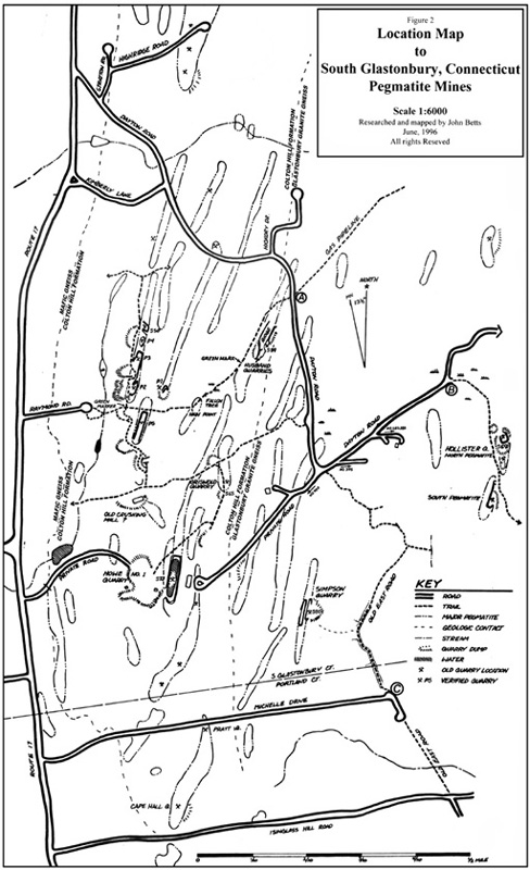 |
| Figure 2 - Summary map created for this article of quarries and trails in the area covered in this article. |
© John H. Betts - All Rights Reserved
DO NOT CALL THE OWNER OF THIS WEB SITE REQUESTING PERMISSION
OR MORE INFORMATION.
EVERYHTING KNOWN IS PRESENTED HERE ON THE PAGE.
This locality information is for reference purposes only. You should never
attempt to visit any mineral localities listed on this site without written
permission of the land owner and/or mineral rights owner and that you follow
all safety precautions necessary to protect yourself and the property.
Unfortunately, the status of mineral collecting sites change often. Inclusion
in this site does not give an individual the right to trespass. ALWAYS ASK
PERMISSION prior to entering a collecting location. ALWAYS RESPECT THE PROPERTY
OWNER, you are his guest. Never enter a property posted no trespassing. When
in doubt, do not enter the property.
John Betts - Fine Minerals Home Page
Please support our sponsor

© John H. Betts - All Rights Reserved
